
- Happy Birthday - June 18, 2026
- Lumix S9 - May 27, 2026
- South Korea Motorcycle Tour – continued - May 22, 2026
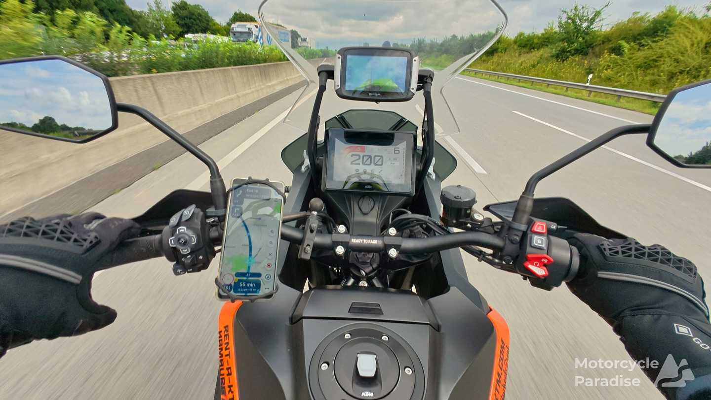
On my USA tour I got to use the new Goldwing navigator and realised again my navigation setup was dated.
Besides my ill fated look at Apple Car Play (which stopped working after one tour) I have been using a 2009 Garmin Nuvi 765 as my navigator outside of Japan and a Garmin Zumo 660 in Japan (which was stolen by Aus Post couriers when shipped to Australia).
 I’m not always Captain Cheap Charlie and decided to leap into the future and buy a new sat nav.
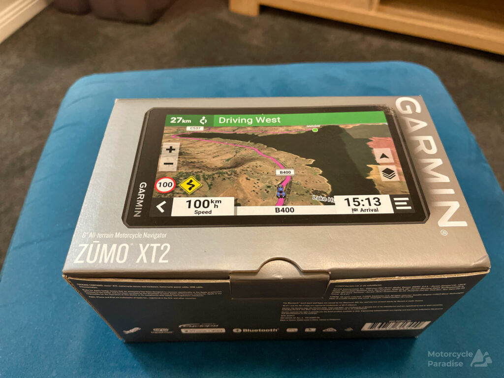
Reviews of this new device were all glowing – but we live in a time when Motorcycle Writers and YouTubers are puppets of manufacturers. They give positive reviews to everything to keep getting bikes/gear to review and often just rephrase the provided press release material. Honest reviews are rare now and it became apparent I had not read any once I started using the XT2.
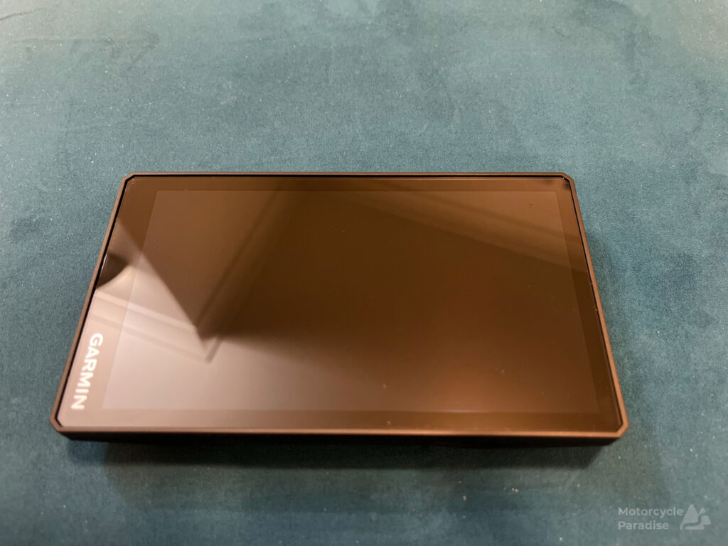
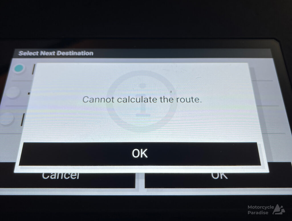
I cannot recall buying such a poorly performing device for a very long time. The software in the XT2 is incompatible with existing file formats and renders the XT2 unable to do the most basic task of guiding me along a custom route uploaded to the device. The applications in the XT2 freeze or crash, even routes made inside the device can end up not being assessible.
Here are some of the issues I encountered:
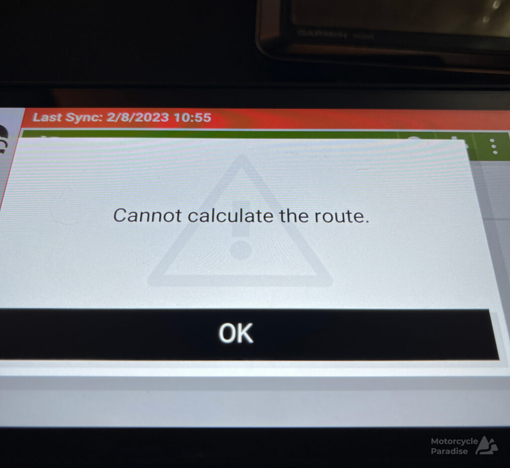
It is not compatible with .gpx files from online route planners. It recognises the .gpx files but then crashes/freezes when trying to calculate the route. If you transfer the file wirelessly to the XT2 using Garmin’s new Tread app then it tries to calculate the route then gets itself in a endless loop or freezes. If transferred via USB cable then the XT2 just refuses to load the files.
The XT2 is the first Garmin GPS not compatible with Garmin’s own route planner Basecamp (and that is Garmin confirmed). Route files made with Basecamp and transferred to the device show as tracks in the XT2 but cannot be converted to routes. The device has a internal Track to Route convertor but this program freezes on the conversion or it creates a route but then this file cannot be read and calculated by the XT2.
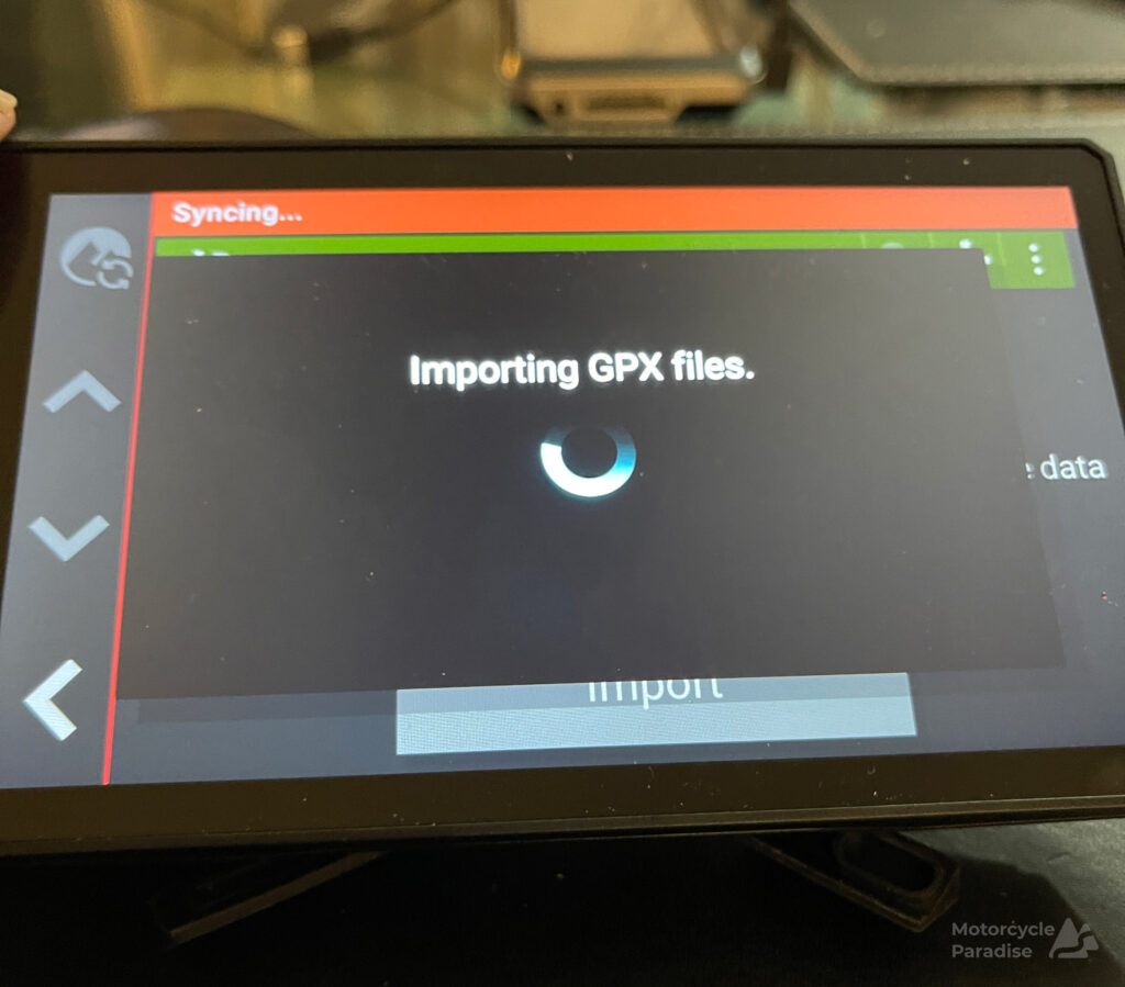
The new Garmin Tread phone app has a convertor also however tracks converted with this to a route also crash the device. The device can actually display the uploaded tracks on a map but you get no turn by turn guidance with tracks in the device. That function is only provided with routes which the device is unable to use (if created external).
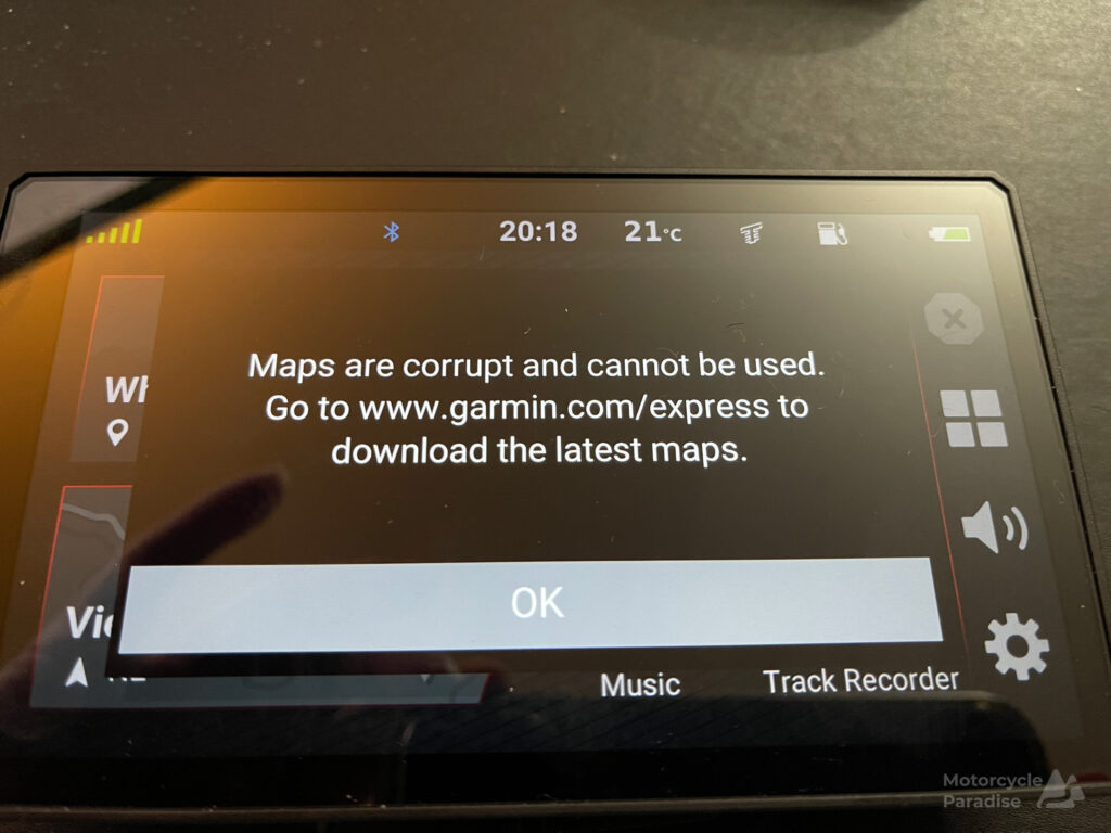
Overseas models allow you to add any countries maps via Garmin Express app but the Australia and NZ sold model is region locked and does not have this feature. It recognizes Open Street Map files inserted on a SDcard but won’t allow you to plan a route for a OSM only for the device internal base map. It will not read genuine Garmin maps in it’s SDcard slot. I tested a older genuine Garmin map on a SDcard which works fine in other Garmins. I tried it on a few different size and make SDcards but that is not the problem either and the file is not corrupt.
Using the Tread app you can make a custom route on your phone (with the limitations involved of doing this on a small screen) however only for the maps installed inside the device main memory, not for a overseas OSM in the SDcard slot. Despite advertised as the device for riders on a world adventure it seems to have a dumbing down of functions to make it region locked to use only the base maps and only routes made in the device or on Garmin’s phone app for the base map.
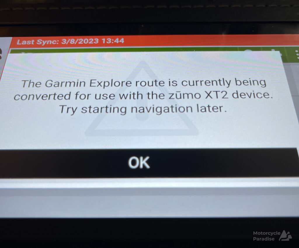
But even that does not work well. Transferring a local route made in my phone with the Tread app to the device it appears in the menu but when you try to access it you get a message to wait while it is being converted for the XT2. This can take from 1 hour for short routes to a whopping 12 hours (no kidding) for long routes. It is terrible. Imagine making a new route on tour then being told wait hours for the device to convert it.
I have been on the Garmin support groups and tried everything that has been suggested by some pretty hardcore GPS geeks there. Different ways of transferring, different gps file formats, different online planner tools, using basecamp, less waypoints, different maps, of course using the GPS simulator mode and lots of device hard resets all to no avail. Tried stuff literally all day and night for a couple of weeks. Nobody could get it to calculate a single custom route for my next overseas tour and agreed with my diagnosis the device seems to have some clumsy coded region lock. There is A LOT of misinformation from people with the older XT model – that model is different, what works for the XT does not work for the XT2.
So I went back to my old Garmin Nuvi 765. It reads any map whatsoever. All my tour routes for each country transferred to it were calculated quickly and are now ready to navigate. I ordered a new screen for it from Aliexpress and will maybe refresh the battery while I have it apart. I’m going to trial a new phone navigation app on upcoming tours also because I really would like to update from 2009 tech but working without a phone signal and having an interface I can see and use while riding remains hard to find in a phone app.
The XT2 went to eBay and is sold. What a POS.


I’ve got a Zumo XT and think its functionality is pretty poor compared to the numerous cycling Garmins that I own. I only bought it because of the screen size and brightness (I can actually see it in bright sunlight). The Zumos seem not to be able to handle tracks/routes with a high number of waypoints. For the XT2 not to be compatible with Basecamp (which is 10 years out of date itself – but does work – if clunky) is ludicrous.
Garmin make a large portion of their profit from fitness/lifestyle units yet seem to ignore their customers needs. Perhaps they are the QANTAS of the gps world? Certainly very frustrating when you need the u it for an international holiday.
Hi Dave,
Maybe I might look for a XT… but I feel nervous about that having been burnt with the XT2.
I am concerned about using a XT with overseas map and have the device calculate uploaded route for that map – a problem in the XT2
I really would like to move forward from 2009 vintage units, they can’t run forever.
But these old Garmins are not restricted, they can accept 100 waypoints work with OSM or Topo or old Garmin HERE maps.
I was using MRA Routeplanner with the XT2 to convert waypoints to shape points to get routes under 30 waypoint limit in case that was issue but still did not help.
Garmin seem to have never been challenged and are lazy. Tom Tom is only alternative for a sat nav that accepts custom routes but they only supply maps for a portion of the world and do not allow use of Open Street Maps.
I think phone apps are finally catching up, MRA with its claim now to be able to auto skip shape points you have detoured around and work without data might a alternative – I will see.
Hi Warren,
While based in Oz, I have used MapFactor Navigator for a number of years upon multiple Android mobiles. While I am not sufficiently versed in comparisons with dedicated Navigators, for a free application using global OSM maps, I am more than happy with this Android application (and recently Windows). I have used the software while riding around South Korea (where I first learnt about the application – for example, the software highlights motorways that motorbikes are not allowed on over there), New Zealand (okay, navigation is simple but must be mentioned due to magnificent scenery and people), Vietnam and around NSW/VIC. In the case of any visual/sunlight issues, verbal guidance via the software and a communicator is excellent.
I am sure holes could be picked in functionality of the software but, as might be indicated for the price (donation), I consider the use thereof to be a no-brainer.
As a side note, thanks for sharing your experiences over many years.
Cheers,
Mike
Hi Mike,
Thanks I will take a look at MapFactor Navigation.
I have stuck with Garmin over the years for a couple of things I have not found on phone apps.
Initially not being able to give phone apps a custom route file to follow kept me away.
Then apps like OSMand, RWGPS, Rever etc all arrived that accepted custom routes but I found them poor compared to dedicated Sat Nav.
Something I encounter every tour is the need to detour or correct my route and with Garmins I simply touch the screen and they switch from birds eye turn by turn to overhead map view.
I can then pan and zoom and see what road need to be on all while riding and wearing gloves.
Easy enough on minor roads to stop but difficult on expressways when I have taken wrong ramp or in cities.
I am going to trial My Route App navigation on my upcoming rides but will carry my Garmin as backup.
A follow up to this – I tired MRA on my Romania ride and it was terrible.
Like so many other phone apps when I missed one of the waypoints because the road was slightly different to the map MRA then refused to skip this and tried to route me back to that point even after I had gone past waypoints later in the route.
It is advertised to not suffer from this problem but it does and ended up being useless.
Pretty harsh…🤣🤣🤣
The Zumo 2 needs to be used with Garmin explore, I have a ten day trip to Spain & France coming up and all my routes are on my Zumo having been saved in MRA and imported to explore in GPX 1.1 or 1.2 neither really matters as Garmin don’t seem to recognise waypoints or shaping points unless created in their software, tinkered with and then sent the ‘track’ to the Zumo with the tread app once on the Zumo convert the track to a route…sounds convoluted but takes minutes.
The problem here that people can’t get there heads around and it took me a while!!!! Is that Garmin are trying to create a world where everything syncs without a data connection.
Andy.
Hi Andy,
Are you in Australia or elsewhere?
Garmin Explore was not available to me in Australia (and far as I know is still only available for owners overseas but if this has changed then I’d love to know). Additionally XT2’s purchased in Europe and USA can select other countries maps and have them downloaded to the device however in Australia this feature is not available.
Further to this the XT2 Australia version does not recognise any official Garmin maps on SDCards (this is comfirmed on the Garmin forums) only Open Street Maps on SDcards can be used however when using Garmins Tread app to plan a route it does not recognise the Open Street maps on SDCards and only allows planning a route on the internal maps for Australia and New Zealand.
So as of when I owned a XT2 the Australian sold devices were unable to be used to plan a route for anywhere other than AUS and NZ.
I would love to know it the same applies to the Garmin Tread Tablets – I saw a 8 inch version being used by one of the guides on my Colombia ride however he purchased the device in Denmark where there are no restrictions to adding maps. He suggested I buy one from overseas however as far as I know once the device is activated it knows what country it is in and if in Australia will become region locked.
XT2 should never have been brought to market.It has got me into life threating situations in wilderness situations.Screen freezes, when it finally wants to show a map it may swap from vertical to horizontal, road may disappear altogether,occassionally will reboot for a short time.I have never owned such a frustrating and dangerous navigation device.GARMIN_FIX THIS!!!!!!
I picked up another Garmin Nuvi 765 from eBay in perfect condition apart from dead battery. I replaced the battery and total cost has been $38 all up. Placed inside my waterproof motorcycle case using a two wire USB cable and a power bank this is my setup going forward replacing my Nuvi 760 (in same case) which has reliably guided me on motorcycle tours all around the world. Bigger screen would be nice but these old 760 series Nuvi’s have none of the waypoint limitations or file compatibility issues and connect to my helmet headset via bluetooth reliably every time.