- Held Spring Ride Gloves - January 5, 2026
- 100 Motorcycle Tours - December 27, 2025
- Bhutan Motorcycle Tour - December 9, 2025
Update: This post is getting old now and I have finally in 2024 started to use a phone more for navigation but in some countries still rely on my Garmin GPS. I am starting to use My Route App on my phone for turn by turn guidance linked with my bluetooth headset. I switched already to planning my routes in My Route App web site. It is not as user friendly as Ride with GPS my previous favorite but the files it outputs to a Garmin have less errors than RWGPS which has become too bicycle orientated.
I have experimented with Apple car play on my bike in Australia and found in country areas where no phone signal exists it stops working but that will be what I will use on my next bike in Australia as My Route App supports carplay and I will learn more about using it offline. I purchased Garmins latest XT2 GPS and nothing worked in it. Horrible buggy software and the device was region locked to Australia. I’ve sold that and the experience has really made my mind up to move on from Garmin once and for all.
I lost my Japanese Garmin in shipping so am unsure what I will use if I return to ride Japan again but that will not be for quite a few years and by that time much will have changed again and perhaps I will then rewrite this entire post.
Until then here is the former post as written 2018.
Standard navigation apps or simple GPS devices are of limited use for a rider on tour. Regular navigation software is designed to take you from A to B by the fastest route. Like this.
But a rider wants to take all the nice roads so the best route between these two towns can look like below.
A regular GPS or smartphone navigation app cannot guide you along a breadcrumb route like this, it was designed just for A to B fastest way.
To use a custom breadcrumb route like above the app or device must be able to import (load) a route file made in a route planner and it must be able to then navigate along all the waypoints. There are a few apps and a few GPS units that do this but first you need to decide how you will make your route.
Creating your route
There are many route planners. Furkot, Rever, Motogoloco, Harley Davidson Ride Planner, Honda Trip Planner, Kurviger, Tourstart, My Route and the list goes on and on. By all means look at these and decide yourself but major flaw is none except the one I am going to suggest incorporates Google Street View. This is essential when route planning to check road conditions or access to hotel, cafe, highways or fuel.
Ride with GPS is dead simple for beginners yet also allows more experienced planners to edit cuesheet data which is something I like to do in some countries as well as adding custom POI data. That may be just to add a message to myself about a picnic stop or place waypoints where I want to better control the device.
Don’t be put off by the logo which is a push bike, it offers motorcyclists every tool you will need and originally had a different theme, just cyclists came to love this site so that is now reflected in the logo.
The site has comprehensive help page with video tutorials of all aspects of making and using a route but it is so simple, if you can click and drag your route in Google maps then you already know how this works and should be up and running in minutes. Turn off avoid highways option (unless relevant) find your start point on the map, be it home or hotel or bike rental shop. Click on the map and a start point is attached. Click along the roads you want to ride, the route auto snaps to follow the road.
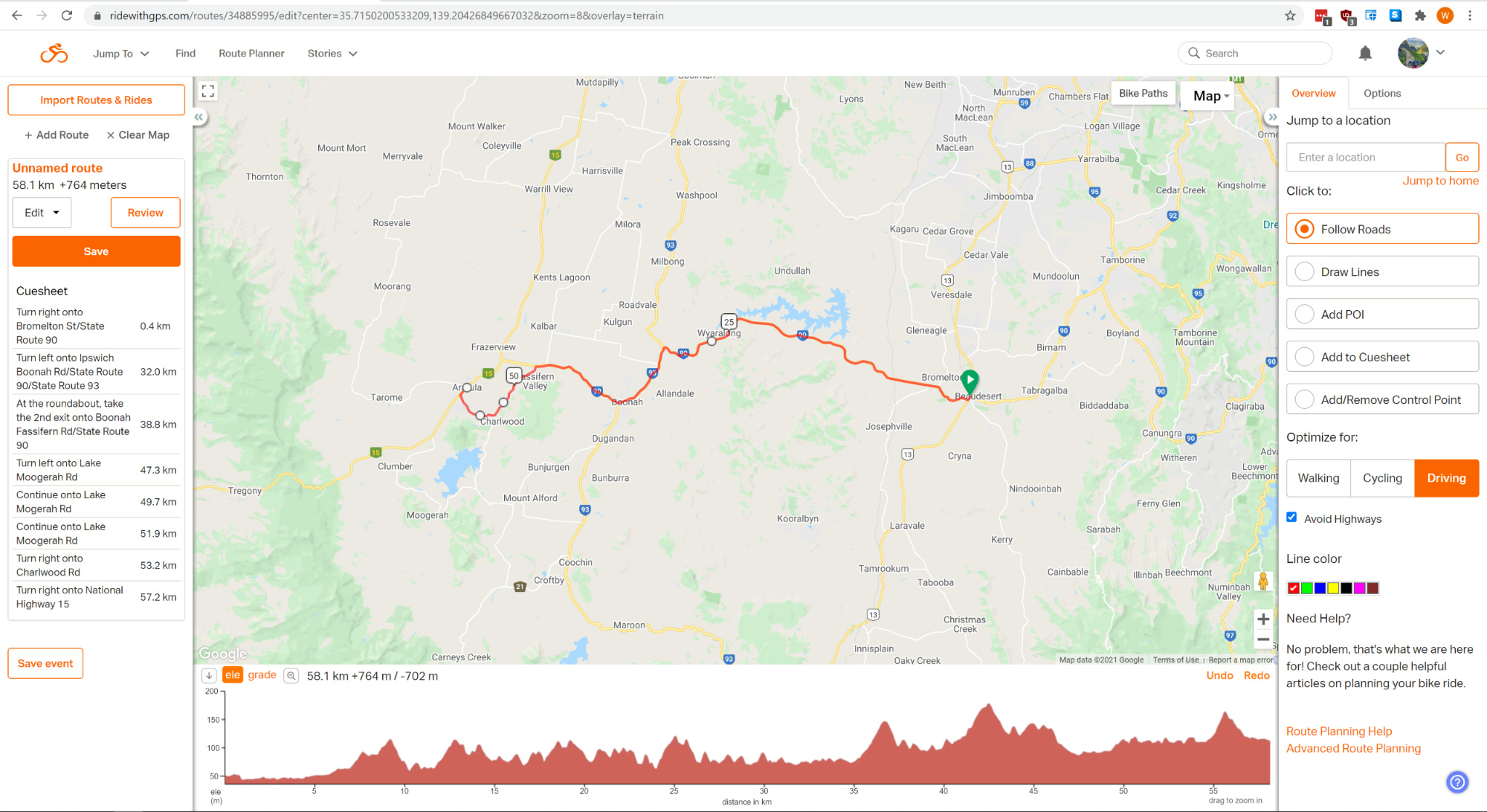
You can undo anything, drag and bend the route, and that’s it you just made a route. Above you can see a simple route I just made by clicking on the roads. Zoom in a little or you may click off to the side of a road and have the GPS want to detour off down a side road a few metres as you ride the route.
You can add a POI point of interest onto your map for visual planning reference but if you want the GPS to give you a special instruction then that can be done via the Cuesheet entries list you see on the left of screen.
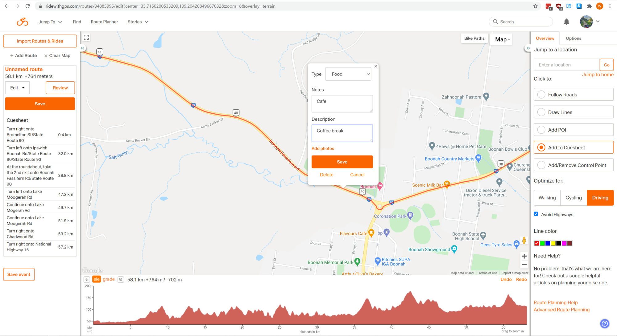
Above I have added a coffee break instruction to the Cuesheet at a location along the route just as an example. Now when you ride this route the GPS will tell you this as one of its turn by turn on screen prompts. (if you use Route gpx file export).
Using route in smart phone
Using the app on phone there is nothing else to do just choose route in the app of same name then press navigate. The app is probably fine for most people but not as good as a GPS unit in my opinion which I prefer but that does take a little more work.
Exporting your route for a GPS
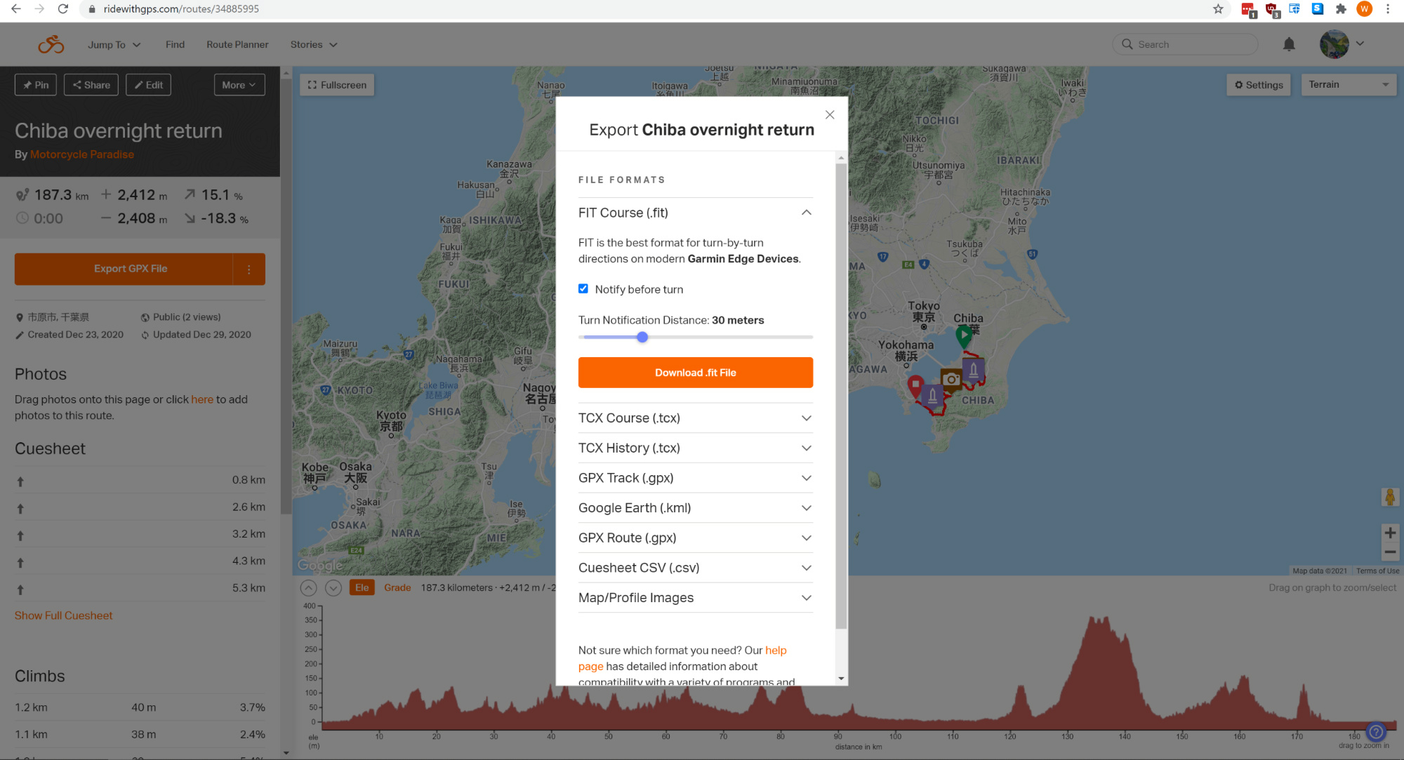
If not using the Ride with GPS app you can export the file as a .gpx file and use it in your GPS. You can choose a few types of files the ones important to our purpose are Track .gpx or Route .gpx file. A Track file is like a breadcrumb route with 1000’s of waypoints the GPS is forced to follow – I don’t find these always work reliably except for off road riding where it’s essential you use that type of file.
A Route .gpx file has all the cuesheet information which are waypoints the GPS has to go to and this works better for me. RidewithGPS suggests using a Track file but this is for bicycles.
Possible issues when using GPS
Something else to be aware of if you are planning in RidewithGPS on a Google map that may have a mismatch with the Garmin map or Open Street Map you have loaded in the GPS. All three are going to be almost identical but there can be differences occasionally, new road junction, things might be a few metres out from one map to the other and this can cause a route to not calculate properly when imported.
Here is an example.
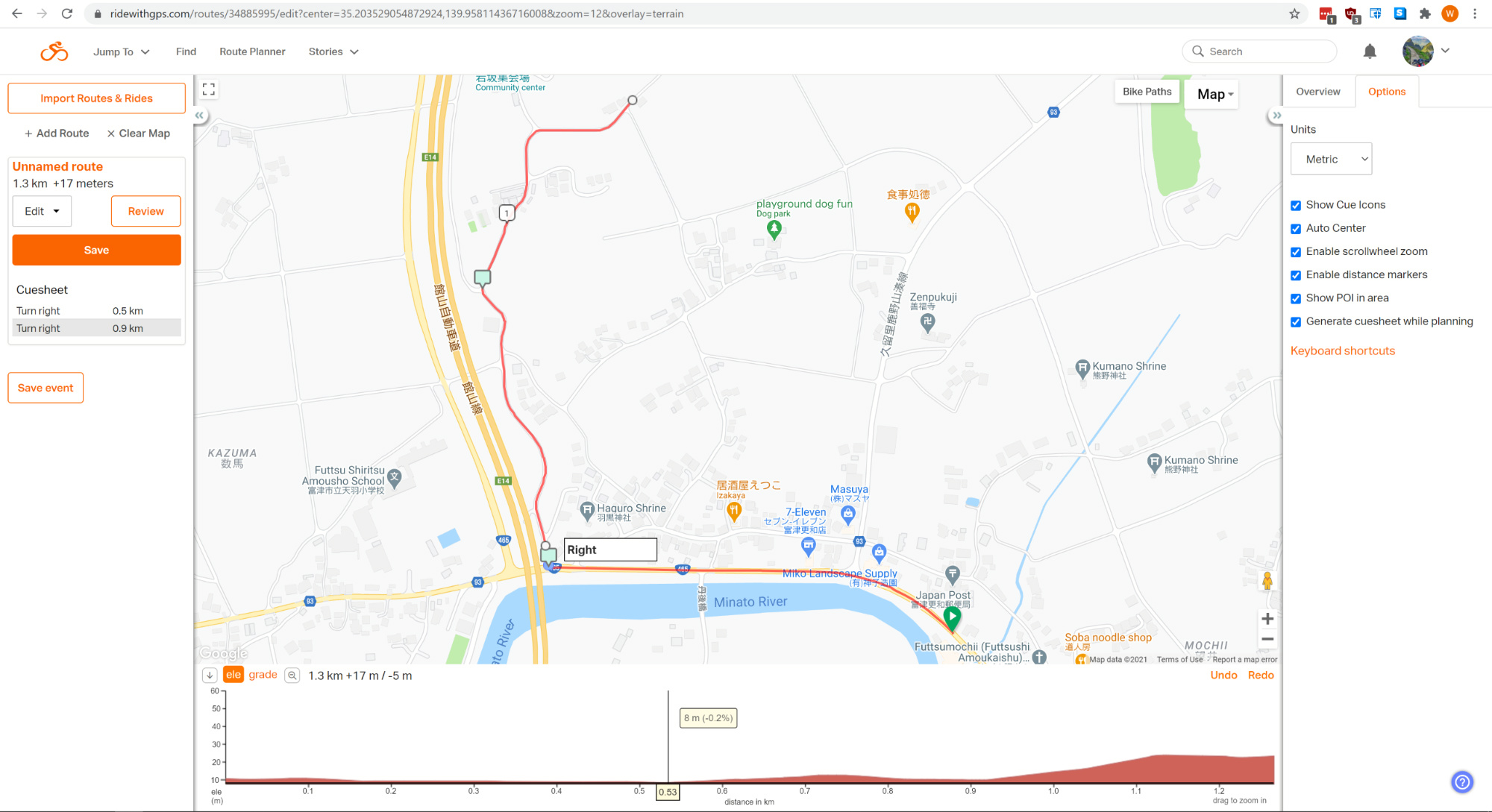
Lets say the above is your route but the highway overpass on one map is a few metres different and so your turn right waypoint in the GPS sits a little to the left on top of the highway. What you then end up in the GPS with is like below. The device might calculate a route that goes north to the ramp then along the highway then off the next ramp and back adding those waypoints before it then tries to resume your original route.
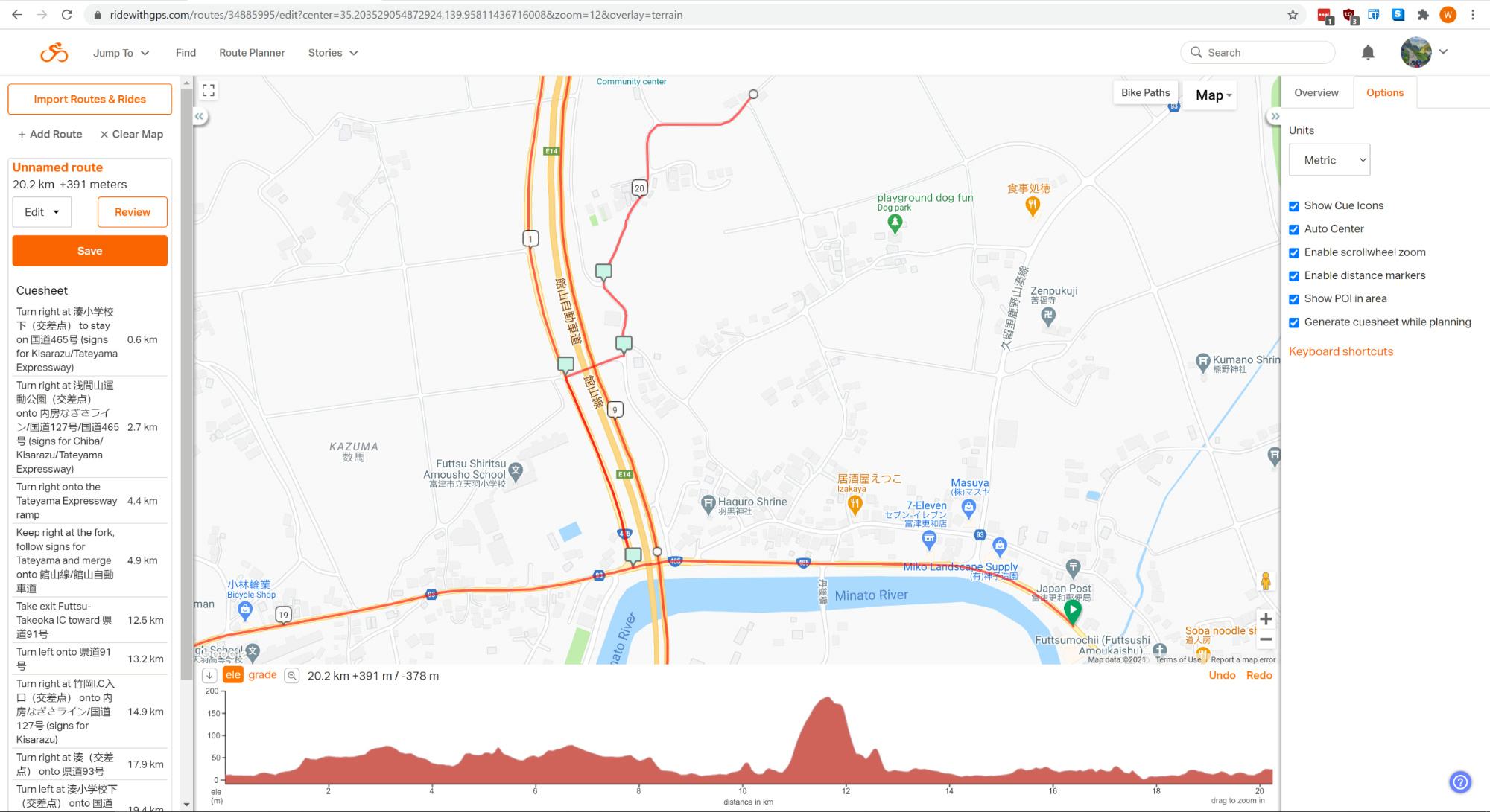
In this situation you might try another map or you can simply edit the cuesheet which is what I choose to do for every route I make. It is more work but it has a few benefits.
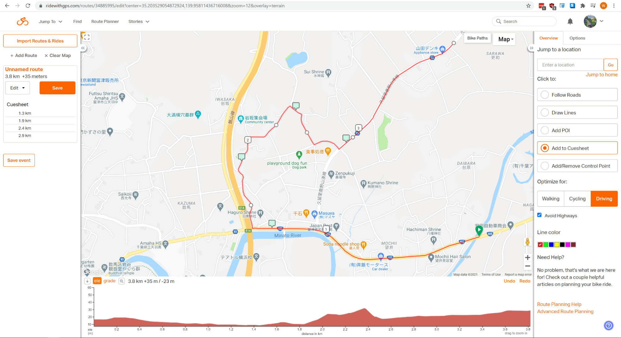
Above I cleared the automatically generated cuesheet entries and added my own entries at strategic points so when the GPS ‘joins the dots’ to follow these points it will not take a shorter way nor be able to get confused if there is any difference between the maps.
That may seem like more work (and it is) but often it can be done quickly and there is another way I use this which is to let the GPS choose the better route. This is something I only do when I am using latest Garmin maps or in a location where it does not matter what particular way I cover some part of my route.
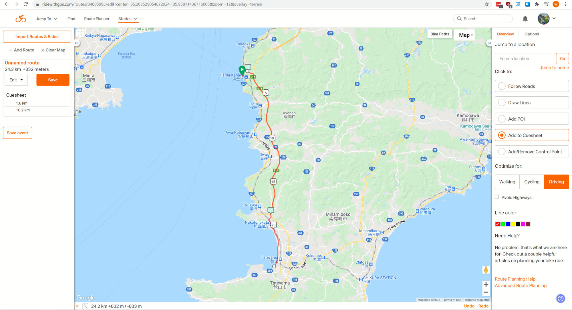
Above I cleared all the cues which were numerous and added just two cues of my own. The first at the top tells the GPS to follow ramp to the expressway and the 2nd tells the GPS to use the road exiting the expressway, naturally in between it can figure to use that expressway. But then I let it decide what roads to take to the park at the seaside. This is a portion of an exact route which I rode and the GPS chose a logical quickest route from the 2nd cuesheet point to the park.
Finally the other reason you may encounter an error in your GPS route from what you made relates to more than one road being at one location. This exists where highways run on top of other roads and can confuse a GPS if you had a cuesheet entry exactly at the place where two roads sit on top of each other because the device asks which road are you referring to. I found the easy way to avoid this is by removing any cuesheet entries on elevated expressways, in between where you join and exit it will always take the expressway unless you have your device set to avoid highways.
You can generally leave all the other cuesheet entries and have none of the problems I mentioned with the junctions, the accuracy of maps continues to improve all the time but if you see your route in the GPS is not what you planned then it is likely one of the map problems I mentioned.
Route creation and export for GPS summary
When planning my rides I mostly use this method. Create route in RidewithGPS, clear all the cuesheet entries and add my own cuesheet entries some of which include custom messages to me like the cafe example. Export the file as Route gpx format to my computer.
To use the file in your GPS simply copy it to the GPX folder of your Garmin. Not able to advise for TomTom since they have no maps for Japan or third party map support. Re start your Garmin and the device will prompt you to import the file when you turn it on. If it doesn’t go use the My Data button and select import, then you can view the preview the route on screen and pan and zoom along the route to make sure it matches what you planned.
When following your route it is important to know if you miss a waypoint then the GPS may try to route you back to that point because it is just following each one in order. The easiest solution (when using a Garmin) is touch the screen to take the device from birds eye view to overhead map view and simply ride yourself back on course. However if you veer off course and the next waypoint is some way off still then of course the GPS will automatically recalculate and bring you back on course.
This is one of the reasons I find it better to not to use the automatically generated cuesheet (waypoints) and to insert my own only where needed.
Other smart phone apps
Most people using a smartphone create a route using Google Maps then save that and use on phone via Google Navigation app. However you are limited to a few waypoints and Google may still try to reroute you how it thinks is best instead of via your preferred route.
I use Google navigation a lot on foot in new towns to take me to shops or attractions and occasionally to get me to a destination the fastest way on two wheels but I find it not very good at following a custom route due to it’s limited waypoints and strong desire to take fastest way.
I’ve tried almost every phone navigation app however most are poorly implemented.
I found Rever worked well but I did not like its web route planner. I would use that if I had apple carplay like the new Africa Twin does but do planning in RWGPS. Kurviger also worked but again I did not like the web route planner.
The best app in my experience is same as best planner – Ride With GPS, (no affiliation). The app was overhauled in 2020 and now works much better than anything else on the market with much improved route recalculation when you go off course.
GPS Devices
I prefer a GPS to a Phone and I wrote a length comparison as part of this post originally but a quick summary – compared to my Garmin the phone app graphics are poor with no junction guidance like pictured below.
Phone glossy screens remain difficult to see in daylight compared to the matt finish of my Zumo GPS screen.
Phone apps are almost impossible to operate while riding with gloves – and panning and zooming the map is something I do all the time with my Zumo.
Recently vibrations are damaging the cameras in new phones. If you need to buy a 2nd phone then claims of saving money by phone navigation fanboys becomes void as you can buy a used Garmin for less than a used phone.
A couple of images showing why I find Garmin GPS navigation display still superior to phone app navigation.
Big easy to see graphics with detailed junction information.
Compare this to the simple graphics on apps and it is easy to see why the GPS device has not yet been bettered – however that day is approaching.
If buying a Garmin then do take care to get one that can import a custom route as written about above as not all models can.
All the Zumo motorcycle models can do this but not all the Nuvi car models. Why might you choose a car model for riding? – because they are much cheaper and can be easy installed to a waterproof case.
I use a Nuvi 760 in a case for my travels abroad. While not as good as a Zumo this might be enough for your task and it certainly works well for travel and renting bikes as easy to fit and just use a power bank to run.
You can buy an older Nuvi which will accept custom routes for as little as $30. I did and refurbished one very easy which I show in this article. I talk further there about the models you might use but generally the 760/765 series is cheap and bulletproof.
Finding a good handlebar case/mount for using a Nuvi is no longer as easy as it once was since the company making the SoEasyRider cases I use changed the design to something crappy but there are many in bike shops and online at ebay or aliexpress. Just remember you want it to hold the GPS and power bank and be easy to install and remove. Also know that the Garmin requires a two wire only USB cable to run from a power bank, using a regular data cable will make it go into data transfer mode.
Summary
Sorry this article jumps all over the place – it has been rewritten as things change and now is disjointed.
Have a look at Ride with GPS for route creation and navigation and see if that meets your needs, for more advanced guidance then consider a Garmin GPS, older car units in a waterproof case are cheap, a dedicated bike unit while expensive gives you the best navigation solution.


I have your blog linked on mine. I find your discussions very worthwhile and well-thought out. Thank you for this piece as I am frustrated with my lack of knowledge of GPS and Smartphones..
Hi David thanks for the link, I am reading all your adventures in my home country now 🙂
Thanks for the post. I tested "Ride with GPS" on a short ride today, and it was great and easy to learn! I'm planning to use it for my trip around Mae Hong Son…
You are welcome. I am riding around Northern Thailand soon also.
Excellent article. This pinpoints all of the challenges I have encountered in learning to create custom MC GPS routes and offers a set of solutions for each one. Much appreciated!
Thanks Chris but that article was really poorly written and out of date. I’ve now updated it a little.